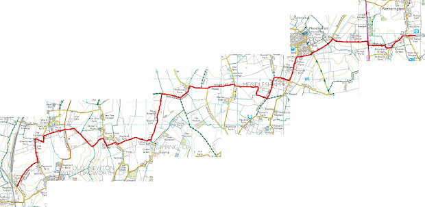
Mid-Suffolk trail
I recently happened across a YouTube video detailing on guy's journey through the appalachian mountain trial (all 2200 miles) which I "think" was partially from his disappointment in life circumstances or discontent at the state-of the world. I guess you call call it a coming of age type tale, but gimme 20-30 years to figure out if that's true or not...
Either-way, from it I recognized my own unhappiness (yadda yadda) and thought "hey this is a cool idea, I could do that too"
2 hours of internet searches later, I figured 2200 miles of hiking over 6 months, and buying a bunch of gear I wasn't 100% familiar with was probably not the smartest idea.
But what if there was another trial near where I live that wasn't so ridiculously long and could be done in a day? There is as it turns out. It's approximately 20 miles and not considered too difficult to walk by a couple of folks.
https://ldwa.org.uk/ldp/members/show_path.php?menu_type=S&path_name=Mid+Suffolk+Footpath

There's even a couple of blogs talking about previous experiences (one very wet and another in two parts)
https://maxineoutdoors.co.uk/mid-suffolk-path/
https://reinterred.blogspot.com/2019/03/mid-suffolk-footpath-part-1.html
https://reinterred.blogspot.com/2019/03/mid-suffolk-footpath-part-2.html
So I drove to Hoxne, parked at Brakey Wood, and set off to the starting point thinking:
How hard could 20 miles in a day really be? (the reader is asked to refrain from laughing at this point)
Part 1: Beginnings and walk to Bolser Bridge, Eye
Starting from the picturesque bridge (see below) at 9:30am I set my sights on Stowmarket. To begin with it was quite a warm day (~18degreesC), and the start of the trial was mostly downhill through Hoxne until the path takes a right across the River Dove towards Oakley, where there is a driveway covered in bluebells and later down the path a wonderful gram-worthy view of the river meandering.


Bridge at the start of my hike in Hoxne (Top left), bluebells in Oakley (top right), Views of the River dove (bottom left) and the crenelated building (bottom right).
I'll try to spare some specific details for brevity, there is a farm just down the trail which has a lovely crenelated tower. The trail goes south around the outskirts of eye until coming to Bolser bridge where I stopped for snacks at 11:08am. My pedometer recorded ~10577 steps or 7.5km. I'd made good progress, taken some cool pictures and got my step count, so felt great. At this rate I'd be in Stowmarket by 4:30pm (7 hours for total trail).
Part 2: Eye to Thorndon Black horse Pub
Following a punnet of raspberries I travelled on with mildly renewed vigor, and on the trail southwards there was a carved wooden statue of a man's head. At another point I had to walk through someone's front gate which was apparently part of the public footpath, which was a little weird.


Wood man statue near Eye (left) and St Mary's church in Braiseworth (right)
The path went south into Braiseworth, where a lovely lady knew the directions of the path, which goes directly through farm buildings (again a little awkward but not unbearable). Then it came onto the ruins of St Mary's church, crossed the River dove and walked 100metres up a completely different footpath. The path then leads into Thorndon wood which is perhaps the most beautiful section of the trail. One particularly muddy section left me with wet socks and a burning desire to get a walking stick. After some tribulations with the path I emerged from the trees, where the path had turned into a little stream...


100m along the wrong path just south of Brasieworth (left), and the "Path" (more like river) exiting Thorndon woods (right).
I arrived at the Black horse around 12:45pm to find it closed on a bank holiday Monday of all days, how dare they (!) I took 10 minutes to have some water and snacks, at this point my feet were beginning to hurt a little (mostly from pressure being put on parts of my skin folding over) so took my shoes off for a little bit. My pedometer had recorded another 8629 steps (7km) and at this pace I'd finish in another 4.9 hours (5:40pm).
Part 3: Thorndon to Somewhere in a field near Thwaite
After asking some strangers for water I continued onwards, trying to remember the lyrics to "The road goes ever on and on", and it continued eastwards through some fields, one of which had at least 20 cows in it. Normally this wouldn't be an issue. I felt anxious. I'm not afraid of cows. Cows aren't scary. But there's a part of me that sensed the danger of 20-ish tonnes of meat and hooves hell-bend on herd-mentality. Nevertheless, I managed to make my way through the cow field with little issue or fright.


There was another wooded portion with a large area of dead trees and sticks, but also muddy paths. At one point I almost almost fell over and shouted "Balls!" only to find two eight year olds out walking the opposite direction with their dad, that was awkward...
The next part just before the trail is quite exposed, the turns onto the road leading to the A140. This effectively marks the halfway point, and shortly down the lane the eye wind turbines are in the distance (see above). I'd gone halfway by 13:30 (or 3 hours) which suggested a 4:30pm finish - but I wasn't going to be walking as fast as I had at the beginning again...
The path turned south for the last part of this section, directly through the fields, but this didn't feel so bad because it was pretty clear where I was headed. I liked that the telephone mast which was visible for most of the trip also gave me a sense of direction. After clearing this field I stopped for another break at 13:48 and had some more snacks and the stranger water. My pedometer ran out of battery* somewhere around 23k steps I later found out, *note to future self, pack power bank
Part 4: Thwaite to Tan Office (East of Mendlesham Green)
After giving my feet about five minutes to breath, I set off again with rather unmild vigor down Wickham road, then found out I had missed the southern turning so doubled back on myself. The part of the trail was quite challenging, mostly because my feet had started to hurt quite badly and there was barely any scenery along the gravel road. I hobbled for what seemed an age (like 30mins IRL) until the road gave the wonderful view of Mendlesham town and church. Mendlesham marked 3/4 of the way in my head but is actually like 66% completion so I took another break for my feet.


View of Mendlesham (left), the church in the town (centre), and the accursed section of trial viewed in OS form (right).
The first half of this trial was great but I had to slow my pace if I was going to finish it without injury or incident, after making my way into the town the trail turning into slightly warm and unforgiving on the feet concrete... I searched for a bench along the road - but none were to be found - even by the church. Continuing along the lane I reached - congrats if you guessed it - ANOTHER gravel path through for different farms. But it should be said they did have some cool ponds and there was a funky farm name.


Yes that's the name of the farm (left) and the never ending southern gravel road (right)
After passing through these I took another rest by Tan Office Farm at 15:27. I gladly ate more of my diminishing snack pile, and drank some of the stranger water. at this point I'd done 70% of the length and was taking frequent but not long breaks. The last section had taken 99minutes and was ~6.3km
Part 5: Tan office to Stonebridge ford
I set out again with unrenewed vigor for the last of the main section of the trail, internally begging to see a sign that said Stowupland. The OS map initially and genuinely led directly through someone's back garden in Tan office, then I took another wrong turn a was slowed through the long grass until I happened upon the road to Mendlesham green anyway. I took a quick snack break by the phone booth eating my last banana, then headed around the rear of the village where there are some horses in the field.


OS view of going through someone garden (left), the sign in Mendlesham green (right), and a view of Gipping great wood (Bottom)
I continued on the trail going eastwards and the OS map said to head directly across the field onto the main road, I couldn't find the path so headed via Palgrave farm - which as it turns out is private land and on a private road *INTERNAL SCREAMING* - apologies Palgrave farm for that unsolicited walk-by.
However, the road joined to this private road had - *drum roll* - A Stowupland Sign!
Anyway continuing my journey south and east along the trail up a small hill, which has a lovely view of Gipping Great Wood at the top, this road also felt like forever with the blisters on my feet. I continued on the trial down the hill, along the river until I found - not a bench - but a giant log! Which is the only thing on this trail that resembled a bench... But I was happy to take seat on something other than the ground. Didn't stay there long before arriving at Stonebridge ford at 17:25, with achy knees to match my sensitive feet.
This section took me just shy of two hours (and is ~7.5km). I had no snacks in this break, only one GoAhead bar left which I was saving for the end of the line.
Part 6: Stonebridge ford to Stowmarket
I wrestled myself to my bruised feet and lamented my knees, which were probably taking a hit from the change in walking gait I was using to minimise the impacts to my sore feet. I tried taking some heart from the fact I was nearly there, but I'd been saying this for the past few miles with little to show for it, until....
I heard the rumble and clickity-clank of the concrete slabs on the A14. It was palpable. I was nearly there. I took yet another break at the intersection by Newton bridge (at 17:51).
The trail then goes across the railway tracks and through a couple of fields before heading out onto the A1308 footpath. At this point I wasn't sure if it was over or not, so I begrudgingly hobbled towards the Stowmarket sign, and when I gave up all hope (and my walking stick) it turned out there was another marker, which marked the end of the line!


The point where the sound of the A14 concrete slabs was palpable (top left), the turning at Newton bridge (top right), at the Stowmarket sign (bottom left) and then at the actual end of the line (bottom right)
So my mission was accomplished at 18:20 meaning it took a whole 8 hours 50 minutes to complete. Although it was a little slow, I'm glad I persevered to the very end of it. I did also measure my weight before and after with no clothes using a health scale that estimates some health parameters - as a point of interest:
Before - 71.9kg, body fat 18.2%, water 54.1%, skeletal muscle ratio 44.1%, subcutaneous fat 14.1%
Fully laden at start - 80.6kg (clothes, backpack, coat, wallet etc...)
After - 71.4kg, body fat 17.4%, water 54,6%, skeletal muscle ratio 44.6%, subcutaneous fat 13.6%
To be honest I would have weighed less at the end were it not for the fact I rewarded myself with a walk into the town centre for dinner at spoons. But otherwise 20* miles has clearly done somethings good for my body even if my feet and knees currently hate me.
In hindsight could have brought more water, I had 2 litres and need half of that refilling along the way, and more snacks the 2 bananas, 3 GoAhead bars, 150g of raspberries and 2 chocolate roll bars (sue me I like em!), just wasn't enough.
Another thing was that my trashy trainers just aren't cut out for hiking this long a distance (unsurprising though) and I will inevitably get some boots - that will also help prevent my socks from getting wet too. My socks did a pretty good job but the baggy-ness in place may not have helped my feet.
I digress, this was supposed to be for me to take stock of myself, although this took longer than planned but it was mostly through simple mistakes rather than outright foolishness. There were points at Mendlesham and Tan Office I thought about turning back, or getting a taxi out of there - but I'm glad I didn't. Consider this a written acknowledgement of me eating a slice of truly humble pie.
It's no appalachian trail, but the hiking was great, there are so many nice little things to see, take pictures of, it really can be fantastic to get absorbed in the countryside, forget all the general bleakness of the internet and focus on just one purpose.
So I'll see you when I do another character building experience on another trail or trek and Y'all get to hear about it...
Until then
Oscar
Comments
Post a Comment