Middy railway footpath
Well hey there,


Prepare yourself for another edition of "Oscar walks far and regrets it the day after", with pictures of course. Emboldened by my previous efforts on the last trail (not to mention the recovered feet) I set my sights on yet another hike of sorts. Except this time around preferring not to use public transport to return - the train ticket and taxi fare from Stowmarket to Hoxne was £26...
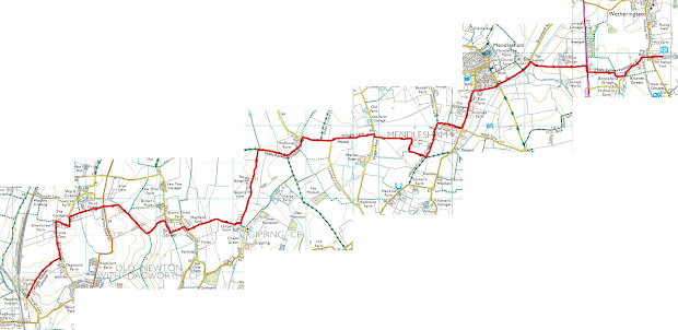
One of the nearer paths to me is called the Middy (Mid Suffolk) railway footpath, which probably has something to do with an old railway line, but I shan't venture to butcher it's historic background. Nevertheless, this runs from just south of Wethersett, down south but mostly westwards and ends near Haughley. Based on some quick calculations, it is roughly 7.5 miles long (or 12km), based on the view of the path from the stitched StreetMap images below.

So following some quick calcs I figured I'd easily be able to walk this trail, and more importantly back in a day. But for the purposes of this I just cover the journey westwards as there doesn't appear to be much on the interwebs about this trail which isn't about the railway station...
Part 1 - Wethersett to End of wimble lane
I started out on the trail around 8:50am, it was a mild 15 degrees and overcast. The path starts out just near the Mid Suffolk light railway and follows the road west, heading through a field which has views of the telephone mast and the surrounding landscape, before crossing the A140. The footpath then follows the road into Mendlesham where it crosses the Mid Suffolk trail going southwards.


Start of trail at Mid Suffolk light railway (top left), first bridge on trail (top right), the footpath has horse poo on sale! (bottom left), and a where the footpath crosses the Mid Suffolk Footpath in Mendlesham (bottom right)
I then followed the path along the bottom edge of the town where it goes along Old station Road, and past Mendlesham woods - Which you literally have to visit. I took a brief detour here, and snacked on some of the food I had.


Path through (left) and seating area in Mendlesham woods (right)
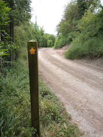
When I tried to re-join the footpath I ended up going too far down the road, but this lead me on track thanks to an adjoining footpath also going westwards. It has some lovely views of farmland going west before I ventured through wimble lane. It should be noted that in many sections of this trail are far less than often trod, so the grass is quite tall, this particular section of the path, however, pales in comparison to others. There were small parts where this footpath that resembled Mirkwood, future hikers are recommended to bring a machete for this section. At several points I was stooping and dodging through overgrow bushes and tall nettles, not to mention the flies and spiders there too!


View of farmland near Mendlesham (left) and "path" through wimble lane (right)
Part 2 - End of Wimble lane to Brown street
Somehow I emerged from this forest onto the gravel road which I followed until the footpath turned South-West and through a wooded portion and continued for quite some way until it reaches Chapel Farm near Gipping, then turns West and continues to Brown Street.


Wooded section of the path behind Redhouse Farm (top left), the path westwards at Chapel Farm (top right), a view of the wooded section from the south (bottom left), and a turnstile at Brown Street (bottom right).
From Chapel farm it is a short walk to Brown Street, and I arrived there at 11:20am, and this section was roughly 4.4km long.
Part 3 - Brown street to Haugh Lane
After a brief reprieve in a concrete area at brown street I continued onwards, The path initially follows the edge the field before rising over a "mound" (for lack of better word) which I can only presume way where the Middy railway line would've been running across.


Concrete area at brown street (left), mound viewed from the North (right).
After some more venturing through some fields the path goes into Ward Green and quite literally passes through Ward Green farm before taking a left onto Silver street. The road meanders quite a bit here but does pass a very picturesque shed, before the path takes it's final turn right onto some more fields and ultimately leads to the end of line at Haugh lane.


Shed on Silver street (top left), final turning of the trail through farmers fields (top right), the last marker of the trail (bottom left) and an old bridge at the very end of the line (bottom right).
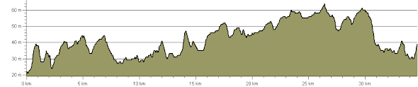
I reached Haugh lane at just before 12:00pm and had my lunch (an orange, a Goahead bar and 70g of Kendal mint cake). This route took me 3hour 10 minutes to walk, and my pedometer counted just over 19,000 steps which was 14.8km by it's reckoning, although some of that I had taken some wrong turns, so it isn't 100% accurate.
To be honest I was anticipating a little more from this trail, and although it's not hugely challenging I was hoping for a little more that simply views of farmers fields. Alas, it appears I was on the wrong footpath for that...
I did also walk all the way back, which took roughly the same time but was only 13.5km (or 17,000 steps) which is probably much closer to the true length of the trail. This makes my estimate for the total trail length at ~13km or 8.1 miles. Though the main point I'd like to emphasize is how my walking pace didn't deteriorate that much (slowest portion was 4.17km/hr) my feet were significantly better than last time despite not taking as many rests as beforehand. That said my knees did not favour me particularly much at the end of the day. Which bring me onto the next point, body changes:
Before: 70.4kg total, 17.5% body fat, subcutaneous fat 13.7%, Skeletal muscle ratio of 44.5%
After: 69.8kg total, 16.6% body fat, 13% subcutaneous fat, Skeletal muscle ratio of 45%
That means after eating two bananas, three oranges, two GoAhead bars and 70g of mint cake I lost: 0.6 kg, ~0.7kg of body fat, of which ~0.6kg is subcutaneous fat.
Needless to say I felt pretty smug, so took a nap as a reward. And the following day my knees ached quite a bit, and although I hadn't got any blisters on my feet (huzzah!), but had developed a small strain in my left foot.
Although the total distance was a little shorter than my last (by roughly 3-4 miles), that may have saved my body from more significant injury too. Pain and inability to move much the next day aside, I feel like this whole hiking thing is growing on me, so guess you'll have to see me on the next one!
Until then,
Oscar

Comments
Post a Comment